This morning Lori and I are up bright and early, suitcases packed and ready to go as soon as we eat breakfast. We packed the car and then walked to the dining room, noting that no one was available to seat us. In fact, as we waited, we noticed that the empty tables weren't being cleaned off and most of those seated had no food. We were finally seated, but it took a very long time for our orders to be taken. (We only had a choice of three items!) We soon exhausted the study of the maps we had brough in with us. Occasionally someone appeared from the kitchen, but the waiting diners were certainly restless. The orders came out very slowly. Rather than drag this out further, let me just say that we spent much longer there than we had intended and were fairly angry about not being informed that there was a problem before we were seated. It was surely no surprise to the motel operators that we were all travelers. They were even slow in checking us out of the motel after we finally ate. We would have had a much better and faster breakfast if we had only returned to the Cactus Kitchen.
Finally we got on the road and drove out of Willcox past the high school where we turned onto Airport Road and toward the mountains on a graded dirt road. About 40 miles northwest of Willcox lies Muleshoe Ranch at Hooker Hot Springs, operated by the Arizona Nature Conservancy. I have hiked there many times and have stayed for several days on a few occasions, including one Christmas stay with my Tucson grandchildren and their parents.
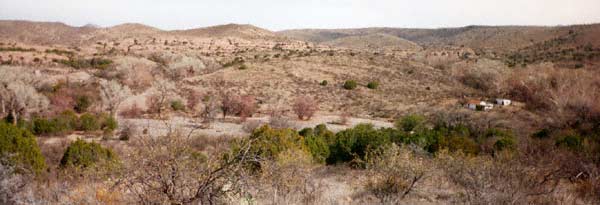
Today we ride in over the high plains road which is sometimes impassable when muddy and along which the other vehicles that I have met are far outnumbered by the hawks and coyotes. I have even seen antelope in the distance. On this road, running north from the Willcox - Cascabel road, you can begin to feel the true isolation in which the few who homesteaded along the intermittent streams back in these mountains lived as they tried to make a go of it in this gorgeous landscape. The farther we drive in along this road, the rougher it becomes. We pass signs for a few ranches but rarely see any buildings associated with them. We pass one corral and loading ramp for cattle. As we near Muleshoe we see one ranch house on the left, above the river. Then we see the white buildings of the Muleshoe headquarters across the river. When we arrive, I am confused at first. The roads have changed here. I park the van and we explore the area on foot. When we reach the riverbed, I remember the rains of last winter. The old road ends at a steep 4-5´ drop into the riverbed where rushing water has widened and deepened the river here. A new road crossing had to be constructed, accounting for my initial confusion. However, the trailhead was unaffected.
With our coordinate system reestablished, Lori and I load up our backpacks, get our waterbottles and my hiking stick and take off up the trail. The beginning of the trail passes through a heavily wooded (by desert west standards) very grassy bosque beside the river. Here a startlingly red cardinal flits among the leafless branched, chiding us for disturbing his peaceful winter home. Other birds which don't remain still long enough to be identified inhabit these trees as well. We suddenly break out of the trees and begin the initial climb. Here the trail climbs steeply along the jeep road, drops slightly and then climbs again. We cross the gas pipeline where someone has pulled out onto the pipeline maintenence road and parked their fullsize van and spread their sleeping bags and blankets out on the ground. As we continue along the road we encounter a jeep occupied by two of the preserve caretakers who stop to ask whether that van belongs to us. Assuring them that we are parked back in the visitor lot and are only taking a day hike, we continue on toward Bass Canyon. After about a mile we reach a high point where we can look down into the canyon. The river is thickly lined with large old cottonwoods. We can see an old abandoned homestead below.
As we descend to the level of the river, we pass a grassy seep where warm water emerges from the earth. Just below lies the cement holding tank, no longer in use, that was constructed to capture and hold this gift from the earth. This area draws many birds and small animals to the haven it provides. When we reach the cottonwoods and the riverbed, we find debris high in the trees, vivdly demonstrating the high water level reached during the flooding last winter. The river stones are more plentiful and their distribution reflects the water path when the water last could move them. Water smoothed stones as large as 10 - 12" in diameter have been redistributed since I was here last.
Just beyond the road crossing, on this side of the river, is thespot where I stopped to watch the zone-tailed hawks in the midst of their mating rituals on June. I was spoken to very harshly by one of the hawks who descended from his flight to land in a branch well above me in an attempt to convince me to leave the area. They must have had other plans for the spot. I finally moved on to his satisfaction.
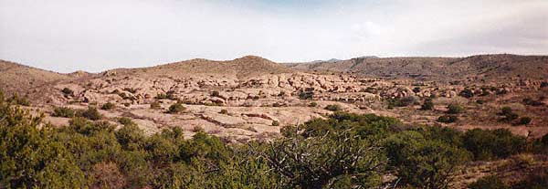
The river crossing now was more treacherous than it had been. With the aid of my third leg, my hiking stick, I managed to make it over the jumble of water rounded stones and gained the other side. Here we climbed again above the river and over into the realm of wind and water carved tuff cliffs where I once played tag with a golden eagle, also annoyed by my presence. He finally flew beyond the reach of my binoculars. Today we climb up to a point high overlooking Bass Canyon and pick our way in from the road, over the "shin daggers" and other prickly vegetation to a block of tuff having an excellent view of the canyon below.
Here we sit and survey the area below in splendid isolation. In the
distance, on our side of the river, we watch a mule deer move slowly
up the side of the canyon, grazing,
entirely unaware of our presence. Because we were using my
binoculars, we had become entirely oblibious to our immediate
surroundings. When the deer moved over a ridge, I refocussed my eyes
and noticed a small ground squirrel just below us, foraging among the
fallen seeds while keeping one eye on us. We saw plenty of signs that
javelina also foraged in this
area. Many small agave
plants were uprooted and pads of the prickly pear cactus had large
bites taken out of them; we found no javelina here at the moment. After about
half an hour, we decided that we would walk a little farther in along
the road. As we continued up the road, the peacefulness and isolation
from the noise and the works of man, even though we were walking on a
jeep road, was deeply impressed upon us. Here mother earth has won,
so far; the homesteaders have abandoned their homes and returned to
regions closer to supplies, leaving their claims to the birds and
other local inhabitants. Now canyon wrens sing from the top of the
cabin while ruby crowned kinglets play beside the pools of
water left by the stream. Bats ![]() make their homes inside the house now. In no direction other than
beneath our feet can we see any sign of the presence of man. It is
with extreme reluctance that we decide that we must turn around and
begin our walk back. I want to take Lori up to the headquarters to
show her the accomodations there and the hot tub filled directly from
the hot springs (Hooker's). There is also the nature trail through
the bosque on the other side of the river and down the hot springs
fed streambed.
make their homes inside the house now. In no direction other than
beneath our feet can we see any sign of the presence of man. It is
with extreme reluctance that we decide that we must turn around and
begin our walk back. I want to take Lori up to the headquarters to
show her the accomodations there and the hot tub filled directly from
the hot springs (Hooker's). There is also the nature trail through
the bosque on the other side of the river and down the hot springs
fed streambed.
As we walk back Lori decides that she wants to take back one of the uprooted agaves that lie near the spot where we sat overlooking Bass Canyon. The one she chooses has a shaft at least 10´ long. For the rest of the walk back I am constantly dodging one end of the plant or the other as Lori swings it from side to side. We even make an excursion down the riverbed, over the jumbled stones to see if we can connect with the hot springs branch and return by that route, but we are foiled by the stones and by my lack of confidence in my memory. For the last two miles I dodge the agave shaft successfully and we decide to stow it in the van before crossing the river (at the new crossing) to visit the headquarters buildings. We found that the van was just barely long enough to accomodate Lori's souvenir. We had to gently bend the stalk in order to get the entire plant into the van and out of the way of the passenger's head.
After successfully storing the agave, we dropped down into the riverbed. From this vantage point we can see just how much of the road was washed away in the floods the previous winter. At the old crossing the road abruptly terminates 4 - 5´ above the current riverbed. After crossing we walk up past the visitor center, in an old stone house, and past the hot tub to the visitor accomodations. Since I was there last, the old section, burned out long ago, which added a sense of history to the buildings, has been rebiuilt to make more rooms available. The caretakers house has also been completed, freeing their previous accomodations for visitor space. In the new building there is a common room with maps and other local information available. As I am known there, the subject of Mt. Graham invariably arises. I do not support the actions of the University of Arizona by my silence any longer.
After seeing the new accomodations, we walk down to the beginning of the nature trail. We continue on through the bosque where the plants were labeled by a group of schoolchildren as a class project. When we reach the streambed, here hardly disturbed, we turn and walk down the waterway. I have spent many hours sitting on rocks along here, allowing the birds to adjust to my presence and to resume their normal activity. Today, though we tiptoe from spot to spot, avoiding the wettest places, we find that no killdeer has taken up residence at the narrow, grassy (& wet) part of the streambed this year (as one did that Christmas). We continue on along the streambed until we are almost to the point where the high trail, which leaves from the stables area, drops down to meet the stream. Here the going gets a bit hairy again so we sit on a couple of the larger rocks and simply enjoy the light, the cottonwoods and the sounds of the birds. As we walk back along the stream, retracing our steps, listening to the Gilas woodpeckers high in the old trees, we see a large group of javelinas trotting ahead of us up the stream. They are moving at a rapid clip but we count at least a dozen. They do not turn to confront us but move off onto a trail headed away from the stream toward the Bass Canyon region without looking back. Soon we find our trail back to headquarters and the new road crossing and return to our van. The sun is starting to dip toward the west and we have a good bit of driving to go before we reach the interstate, and then about 40 minutes more to Tucson.
We retrace the road out to the Willcox - Cascabel road and turn toward Cascabel and the San Pedro River. We drive over rolling hills and through ranches, over a pass and drop down toward one of the last permanent rivers in Arizona. We follow the San Pedro down toward Pomerene, coming suddenly upon a section of the road (dirt) at least 6 lanes wide including a bridge across a wide wash just as wide! A developer must have gambled and lost here. We stil have not reached Pomerene, and there we have yet a few more miles to reach I-10 at Benson.
We near the interstate as the sun is setting. The birds line up on the phone lines, all facing the sun, for their evening prayers. We join I-10 on the east side of the San Pedro river and cross the river while trying to join the traffic flow. This is a great shock to us since we have not been in a high speed traffic situation like this since we drove out of Phoenix. I chose to drive on I-40 , which rarely has traffic this heavy, for only short stretches and somehow, except at rush hour, the traffic on I-25 never reaches these heights. But the fact that I-10 feeds into the Los Angeles - San Diego area, passing through Tucson, Phoenix and Houston makes the truck traffic extremely heavy. By taking the route we have, we have minimized the amount of time we must spend on I-10, but the shock is still extreme.
Our plan is to make our first stop at my son, Robert's, house, where
I will be staying for the next few days til I fly back to Massachusetts.
We will finally deliver the Cookie Monster ![]() piñata to its intended
recipient, Devin. Lori wants to see his reaction when he sees it.
Fortunately Robert lives on the far east side of Tucson so we can get off of I-10
long before we reach Tucson proper.
A quick drive through Vail
area leads us to Devin and Caitlin's home. We remove Cookie
piñata to its intended
recipient, Devin. Lori wants to see his reaction when he sees it.
Fortunately Robert lives on the far east side of Tucson so we can get off of I-10
long before we reach Tucson proper.
A quick drive through Vail
area leads us to Devin and Caitlin's home. We remove Cookie ![]() from his window perch and take
him to the door and ring the bell. When the door is opened, Cookie
from his window perch and take
him to the door and ring the bell. When the door is opened, Cookie
![]() is lit from within and
seen against the dark outdoors. Devin doesn't know how to react. This
Cookie
is lit from within and
seen against the dark outdoors. Devin doesn't know how to react. This
Cookie ![]() is as big as he is,
no longer a small image inside the television set. Devin must be
convinced to come up and touch Cookie
is as big as he is,
no longer a small image inside the television set. Devin must be
convinced to come up and touch Cookie ![]() . He really isn't sure whether to expect
the piñata to come alive or not. Even after we have come
inside and Cookie
. He really isn't sure whether to expect
the piñata to come alive or not. Even after we have come
inside and Cookie ![]() is
standing against the wall, Devin will only cautiously approach him to
feel his blue curly hair. He still seems to expect Cookie
is
standing against the wall, Devin will only cautiously approach him to
feel his blue curly hair. He still seems to expect Cookie ![]() to come alive suddenly but then he
breaks out into giggles. I bring out the beaded barrettes, small
sandpainting magnets and T-shirts that I have collected for the kids
during this trip. Caitlin, always sweet and a bit hesitant (at least
at first, until we get down on the floor together), takes her new
things over to show her mother, Donna. The kids are both tired. We
decide that the better part of valor is for me to take Lori to the
hotel to check in while the kids get ready for bed.
to come alive suddenly but then he
breaks out into giggles. I bring out the beaded barrettes, small
sandpainting magnets and T-shirts that I have collected for the kids
during this trip. Caitlin, always sweet and a bit hesitant (at least
at first, until we get down on the floor together), takes her new
things over to show her mother, Donna. The kids are both tired. We
decide that the better part of valor is for me to take Lori to the
hotel to check in while the kids get ready for bed.
Lori and I drive across Tucson discussing how we are going to negotiate getting the agave up to her room first and then what are we going to do with it, thatis, how does she get it back to Amherst. Checking in is easy. She gets her luggage from the car and I am put in charge of the agave. I have parked at the rear of the hotel to make our entry as inconspicuous as possible. Lori gets through the doors with her luggage, but I am confronted with the fact that the stalk is twice as tall as I am. If I hold it near enough to the top to reach the door to open it, I can get the lower half through before the door closes! I finally wind up standing in the open door and feeding the stalk through until I can get it all in and still control the closing of the door. The next obstacle is the elevator. We manage this by placing the bottom of the agave in the back corner of the elevator and gently bending the stalk until the top was just inside the door. Fortunately there was no one in the lobby during this operation. In this way we got it to the 7th floor and gently reversed the operation and got to the room unobserved. Our plan was to have Lori measure the length of the stalk and the diameter of the basal leaves tomorrow. Then I would go to a home improvement store and buy a sufficiently large piece of PVC pipe and two end caps to enclose the agave for shipping.
Now we had only to return to the car and bring up Lori's petrified wood and sand collection so that she could pack them as well. The complicating factor in all of this was that she was not taking a direct flight back to Hartford, but was stopping in Austin to give a talk at the University of Texas Astronomy Department becuse they had a post-doctoral opening. Lori did not want to take the packed plant to a motel in Austin and then take it back to the airport again for the flight to Hartford. So Lori's job was to investigate shipping options while I obtained the packing container. When we reentered the elevator, we found we had left a few pieces of the agave base in the elevator where we has applied a small amount of stress to get a fit. We were wondering what other elevator riders would make of these when the elevator stopped and an older couple joined us for the ride to the lobby. At this point we had trouble containing ourselves until we could leave the elevator, whence we quickly rushed out the back door and began laughing uncontrollably. When we recovered, we organized the petrified wood and sand and checked the van for any other of Lori's possessions. When we were sure that all was in order, we parted, and I returned to the far eastern reaches of Tucson to spend the next few days with my grandchildren When I got to Robert's house, I unpacked my belongings from the van and began to think about how to spend the next few days. Items that I didn't want to carry with me, Robert would ship from his shop, Broadway Bicycles. Donna had purchased a few items for me from the Price Club; I would ship those too. And I could finally do all of my laundry again!
Tonight I fell asleep without reading more than one poem!
Recommend this website to a friend!
Visit The Sonoran Desert 5000 square miles of silence.
Books on Arizona Hiking and Geology
Subscribe to Arizona Highways
American Indian Art Magazine
![]() Return to the Table of Contents
Return to the Table of Contents