Early Saturday morning (before 5 AM) Lori and I were both up and packing our suitcases. Today Royallynn and her friend and companion, Judy, were meeting us at the Bosque del Apache before dawn to watch the cranes and geese awaken and prepare for the day. It promised to be very cold; after all, it is January and Socorro is at an altitude of ~4800´. We dressed warmly and loaded the van with all our possessions. After giving the room a final check, we left the motel and drove down the main drag to the nearest Circle K to get some hot coffee and snacks for breakfast. We then continued south to the entrance to I-25 and drove down the empty highway in the pre-dawn dark to the San Antonio exit, then through the sleeping town to NM 1 and south to the Bosque. Along this road we passed a train, lights on and engines running, waiting on the tracks, not far from where these tracks cross the road ahead of us. We kept a watchful eye on the train and proceeded down the road to the entrance to the refuge.
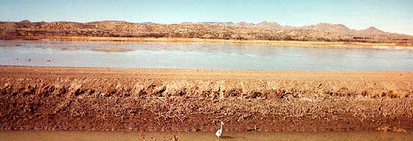
On entering the refuge, we left our daily fee in an envelope (no attendant, but there never is) and drove on to the junction where you must make a choice about which loop to drive. Here there are places for cars to pull off the road and park. It was a short walk from the van to the edge of the shallow pools where the cranes are sleeping. From the van we can keep an eye on the cranes and on headlights coming down the road, where we also see the train still idling on the tracks. We sip our coffee (not good but warm), listen to an occasional stirring in the ponds and nibble our snacks, watching each pair of headlights coming down the road. Then the train begins to move south, slowly at first but picking up speed. We watched as a pair of headlights and the train appear to converge and then crossed without incident. The train continues south beyond the refuge and out of our sight. One or two other cars have entered the refuge now and have also parked, but no sign of Royallynn's pickup. Finally, just before dawn, a small pickup with two sleepy women arrived from Albuquerque. They had no trouble finding us, and we wandered along the roadways/dikes between the ponds watching the increasing activity among the cranes and the geese. It is bitterly cold and our toes and fingers soon feel it acutely. Fortunately Royallynn and Judy had thought to bring a couple of thermos bottles of coffee which were very well received. While watching the wakeup rituals of the birds, with a few small groups of cranes already leaving for the fields to the north, I related the story of my first early morning vigil, at this same spot, two years before. This morning we were not favored with the same experience, perhaps because we were too cold to remain long enough, waiting for the Ross Snow goose community to become organized.
The outside temperature drove us back to the cars to begin our trip around the loop drive. We chose the southern loop because we would be able to see many of the ducks in residence at this time of year. We began the drive in both cars, but both were low on gas. We pulled out at the first observation area where a large steel tower is erected in the winter to allow observation of the water birds from above the tall reeds at the water's edge. Once as I entered this loop I saw a strange object ahead of me, on top of this tower, not human, but large and definitely alive. As I approached, slowly, I realized that it was a golden eagle using the observation tower to watch the ponds. I inched the car forward with my binoculars fixed upon him as he watched me. Finally, knowing that I was not going to disappear, he took advantage of his great wingspan and disappeared himself. Before that day, I had only found a Say's phoebe nesting under the tower. This morning we were favored by neither, but a host of small gray birds were flitting in the underbrush. At this point, we decided that it was foolish to take both cars. We would only court trouble by taking the truck as it was very low on gas. Besides, it was hard to communicate in separate cars. We moved all of their food and equipment over to our van and continued around the loop.
We drove slowly, stopping often to watch the birds and ducks. Lori and I pointed out the buffleheads and the mergansers. I showed off my newly gained ability to recognize many of the ducks at a glance. We also found several great blue herons in the irrigation ditches running along the sides of the ponds, used to control the water level. Twice we saw a bald eagle flying up the length of the refuge from the south, its wings moving slowly and majestically, propelling his large body seemingly effortlessly.
Near the end of this loop, now about noon, we found a young hawk perched in the low trees surrounding a shallow pond. Although irritated by the attention it was receiving from passing motorists, it was not inclined too move to far. It simply tried to find a secluded place in the adjacent low trees. We were all having trouble identifying it. A dialogue began between the occupants of our van and those in another car, proposing and then rejecting possible identifications. We finally concluded that it was a variant of a red-tailed hawk, probably young. Judy wanted to know why we put so much energy into identifying the birds. The easy answer, given then, was that it was excellent practice in observation, noting detail and problem solving. But it is really much deeper than that. By such close observation of another living being, you begin to anticipate actions, to almost begin to think like that being and thus experience a closeness and an empathy with it. There are hunters who go out, carrying a bow or a gun, who never kill but use this solitary time to observe and join with the animals in the forest and field, to become one with them. Deep observation of the landscape also allows you to become aware of things that would otherwise escape your notice and to therefore gain a new appreciation of any landscape so observed.
By the time we complete the loop and recover the pickup (Royallynn driving it backwards on the one-way road until she reached the junction) and then toured the visitor center, it was after 1 o'clock. We were all hungry, and Lori and I had a long drive ahead of us. We drove north to San Antonio and stopped at the Owl Cafe for lunch. Fortunately, since we were late, it was easy to get a booth. Lori, Royallynn and I ordered the green chili cheeseburgers (their specialty) but Judy is a vegetarian so she had to survive on french fries and onion rings. After lunch, the obligatory picture was taken outside of the Owl and we parted ways. Both vehicles were filled with gas, and we bought ice and soda for the drive.
We returned to Socorro along I-25 where we turned west on US 60 and almost immediately began our ascent from the Rio Grande valley to the high plains of central and western New Mexico. We climbed through obvious volcanic outflows on a winding road until, suddenly, the road straightened and was much flatter. The first landmark we passed was the road to Water Canyon in the Magdalena Mountains. I have spent a peaceful afternoon in the campground there watching the acorn woodpeckers, whose black and white faces remind me of koshares, move among the scrub oak trees making holes in which to store their acorns. A four wheel drive road leads upward to the top of South Baldy Mountain where an atmospheric research station operates. This mountaintop was also one of the possible sites for the Millimeter Array Telescope to be built by the National Radio Astronomy Observatory.

In a short while we drive through the town of Magdalena, 2000´ above Socorro, where one of the few remaining soda fountains still operates. About 15 years ago there was a wonderful stone wall, having a painted advertisement for Coca-Cola, there by the highway, the last remaining wall of an old store. This wall finally fell too leaving a hole that I feel each time I drive through Magdalena. The road to the ghost town of Riley, with a few husks of buildings remaining, leads out of Magdalena, north past the cemetary. Beware, you must have a car that you trust to cross the wide sandy riverbed, or walk across. The mining town of Kelly lies in the mountains south of Magdalena.
We still climb slowly until we reach the Plains of St. Augustine at ~7000´. We come over a last rise and the scrub oak drops away and the enormous flat high plains lie before us. On these plains the Very Large Array (VLA) operates here with access to the long (35 km) baselines (separations) needed to allow these telescopes to achieve the high angular resolution that provides so much information on the structure of distant galaxies and star formation regions. The high altitude here minimizes problems caused by the earth's atmosphere. Since Lori and I spent almost a week in Socorro working with the data from this telescope, we stopped at the pullout provided on the highway to pay homage to the telescope itself.
As we near Datil, Lori and I keep an eye out for the lone phone booth, providing communication for the widely dispersed ranches in this part of the state, that we heard about on an Albuquerque news broadcast. However, we never found it. When we reached the intersection of NM 12 and US 60 in Datil, we pulled in at the combination gas station, store and steakhouse there. While we were in good shape for soda, we needed lunch fixins and snacks, especially since we expected to spend most of tomorrow hiking. We browsed the available selections and managed to find some crackers, cookies and sliced cheese after a diligent search. As we had come to expect, we aroused the curiousity of the local residents eating in the restaurant.
We then began our drive southwest. We had been slowly gaining altitude as we approached Datil (7340´) and continued to rise as we drove southwest, gaining a great view over the Plains of Saint Augustine. This broad, slowly grading plain covers many square miles of central New Mexico and is shared by cattle (and ranches) and the VLA. As we drive south, the signs of a past volcanic age are evident in the outcroppings of a thick layer of volcanic tuff. This layer continues with us as we drive south past the towns of Old Horse Springs, Aragon, Apache Creek, Cruzville, Reserve, Alma and Glenwood. At Alma we pass the road to the ghost town of Mogollon and to the Catwalk. Unfortunately we have no time to explore those paths today. At Rancho Grande Estates we turn onto US 180. Just south of Pleasanton we pull into the Aldo Leopold overlook, high above an on the west side of the road. From here we look back toward the east to the mountains of the Gila Wilderness Area, lit by the late afternoon sun. This view, of the classic, almost pure, western wilderness is stunning because you can see no hint of the presence of man, save on the sparsely travelled highway below us. Of course we know that this is not really true. There are guidebooks (see below) to the trails within this wilderness area, but the trails are far apart and give access to interior meadows and mountain views that are truly isolated from the works of man. The Gila Cliff Dwellings, while not officially within the wilderness area because of the road that takes the tourists to the site, are carved out of the tuff in the same way that the Puye Cliff Dwellings and those at Bandelier National Monument were made. Man has been in the area for a long time but has not yet been the main force for change in the region. We spend a little time here dispersing the road vibrations from our bodies and absorbing the silence prevalent here. Because we want to get an early start tomorrow, we must press on long before we are prepared to leave.
A few miles south of this overlook, we turn onto NM 78, heading west over rolling hills cut by streams to Mule Creek. This isolated bit of New Mexico, between the mountains of the Gila Wilderness Area and the Big Lue Mountains on the Arizona - New Mexico border is a beautiful and quiet corner of the west, looking almost like the hills of central California, with a few cattle scattered over the hillsides and fewer than 10 houses seen from the road, gliding up and down over the hills, with streams running across the roadway, when they run. The traffic here is almost non-existant. We pass the small building which serves as a post office and begin the winding climb over the mountains through Mule Creek Pass. We pass wide places where the streambed crosses the road. I have pulled over here in the past to watch the goldfinches flitting around in the underbrush. Someone since has fenced it off making this harder. The climb up into the mountains, carved from the tuff is steep and tightly winding.Our slow pace gives us time to examine the shapes into which wind, water and the intrusion of plant roots have carved the tuff. The high point of the road, where I have camped overnight in the past, has a view of the ranchland to the east. After winding through the tuff forms for a short while, we suddenly come upon a wide area where a pullout has been constructed and stop here. The view is now to the west and down into the carved rock. We take some time to marvel again at the effects of erosion on soft rock, sculpting fanciful shapes out of the cemented ash left by the volcanos which covered hundreds of miles of New Mexico with this ash when they were active.
The drop is precipitous to the west. This is what permits us the spectacular view, unbroken until the next mountain range, the Pinalenos. Unfortunately, from this pullout, we can clearly see the effects of man on the landscape. Apparently some members of the species believe that they are exhibiting their intelligence, and certainly their masculinity, by coming up here to drink beer (predominantly Budweiser) and then to throw the cans over the side into the deep canyon. The effects of years of irresponsible television advertisements can be directly sampled by a count of beer cans and cartons strewn over the roadsides of this country. By my estimate, well more than half of such debris was manufactured by one company, Anheuser-Busch. For that reason, I will never purchase any of their products. After Lori and I pick up what we can safely reach to dispose of properly later, we begin our descent into the valley. The road is very steep; the switchbacks are sharp and barely wide enough for two cars to pass. This fact keeps truck traffic off of this road although I have seen a few mobile homes drive blithely past the sign warning them away. Fortunately I was not behind them. As we come dowm to the lower ground, the road straightens out but still glides up and down over the rolling foothills. A few cars, whose drivers found the slow travel over these mountains unbearable, accelerated rapidly past us on this section. As we approach the junction of Three Way ahead, we pass a long unused drive-in movie theatre, the graded rows and metal posts which held the sound boxes still there, althought it is now home to tumbleweeds and other colonizing vegetation. What was left of the screen would certainly not serve well now. Neither of us could imagine what population it could ever have served.
The junction was aptly named as there were three ways you could go from here. We took the road to Safford, climbing up out of the valley again over the foothills of the Pinalenos. This is beautiful country here. I once drove over it, going the other way in the late afternoon, when all of these hills were covered by golden poppies. I capped that view by spending the night camped at Mule Creek Pass. We drive through Safford, a farming community, and turn south on US 666. This is a straight road connecting to I-10 which will take us to Willcox. On the way we pass the road to the proposed Mt. Graham Observatory which once promised to return prosperity to Safford and the surrounding area.
Lori and I were both hit with "culture shock" when we reached I-10.
Interstate 10 is one of the major east-west truck shipping routes in
the country. It has spawned radio stations that beam their signal out
along the highway for truckers, a fact we discovered when our older
daughter, Kathy, and her family lived in Baton Rouge, leading us to
drive I-10 from Baton Rouge to Tucson several times. The traffic on
I-10 is heavy and fast with a large admixture of double long trucks.
We have a hard time adjusting to the highway, especially since we do
not want to adjust. But we have only a short distance to go and take
the first Willcox exit. We opt for
the Best Western tonight as it is located right at the intersection
where we will leave town in the morning. We are informed that
breakfast is included with the room, which seems convenient for a
fast getaway. Tonight we eat dinner at the Cactus Kitchen, on the
other end of town, a restaurant we discovered on a pumpkin picking
trip with the grandchildren one October Sunday a few years ago. They
have good Mexican food, and the locals all eat there, a good
recommendation. Tonight we get Mexican plates, knowing that we will
soon be leaving the land of good Mexican food. After our meal we
drive back across town, about 10 blocks, and return to our room. Lori
wants to do her laundry since there is a convenient laundry room,
while we watch the news and get the basketball scores. Then we get a
good night's rest. Tomorrow we plan to hike at the Arizona Nature
Conservancy's Mule Shoe Ranch.
Recommend this website to a friend!
Books on Birds
Find more books on bird watching.
Find bird feeders and books on feeding birds.
Other Related Books
Subscribe to Bird Watchers Digest
Backyard Bird News
Wildbird
Bird Watchers Digest
Arizona Highways
See the new Desert Places Series from the University of Arizona.
Visit The Sonoran Desert 5000 square miles of silence.
![]() Return to the Table of Contents
Return to the Table of Contents
