
This morning we had breakfast at the motel before leaving for a day of touring and hiking. Daniel was feeling much better. He was definitely ready to go hiking today, perhaps not 8 miles yet however. After breakfast we gathered up everything we needed for the day, especially all of the information that we had picked up yesterday evening, and climbed into the Prev for the drive to the park. Last night Kathy had rearranged the interior, throwing out the remains of Daniel's hamburger and moving the car seat away from the door so that Steve could more easily get in and out of the car. Now he only had to see over my head. We were on the border of Utah and Colorado. To get to the park entrance that we wanted, we must drive east into Colorado and then drive northwest into the park. As we drove through town, we passed a small park filled with large scale concrete replicas of various dinosaurs that kids could play on. We thought that we might visit there on our return to town, but now we drove east toward Jensen and then into Colorado to the eastern park headquarters and the entrance road. The scenery was spectacular even along this road.
We decided to drive in to the end of the road without stopping too often so that we could take the hike early in the day. Then we could explore by car after we hiked. But this was hard to do; the scenery was more and more spectacular. We could not resist stopping at several spots to admire the handiwork of nature. Especially intriguing was the road down to Echo Park. It was hard to drive past the entrance to that road (a 4-wheel drive road rated impassible when wet) but we continued on toward the trailhead. When we arrived we carefully packed for the hike. The length was significant and we were going to take it slowly because Daniel was still recovering, and we were at an altitude of 7500´. We carried plenty of water and snacks, as well as bird books and binoculars.
This hike will be out along a narrow finger of land, falling sharply away on both sides of the trail where the river makes a sharp turn. We began the walk among the trees of the "pygmy forest," the small trees of the high and dry plateau. In some places along the trail we have an open view of the land below with the drainages down from the higher shelfs leading to the rivers. The land is simply spectacular. The most famous part of the park, figuring most prominently in its recorded history, is Echo Park, near the junction of the Green and the Yampa Rivers. We can see the road which leads down to this place; it draws us all as we can feel the immensity and the solitude of the area. This land is so rugged that most of the exploration in this region has been done on the rivers. The earliest recorded river trip was made by a fur trapper named William Ashley in 1825. The most famous early river trip was that of John Wesley Powell, mentioned earlier, who began his trip at Green River, named Flaming Gorge, the Gates of Ladore and many other geologic featureson that trip. The party rested at Echo Park after running many sets of rapids between the town of Green River and here.
It is so silent here. We can even hear the water, far below us. This is so different from the Grand Canyon and even the Four Corners area. There you are always subject to overflights, from small planes flying low and filled with tourists, to transcontinental jets on the flight path from Los Angeles to the east coast, leaving their contrails criss-crossing the sky. Here it is silent, the sky unbroken by the sight and sound of airplanes. There are no crowds lining up behind you to see the same views. Here we are alone with our thoughts; bird song and the music of the distant water are accompaniments to our musings on the assembly of continents and the raising of mountain ranges. Memory is allowed to bring yesterday into alignment with today. It has been a long time since I have hiked with a four year old. This one (Daniel) seems to have at least a few intimations of his mortality.
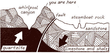
Below us we can see the river(s). It is clear that there must be two rivers but it is difficult to trace the paths because Steamboat Rock blocks our view of the junction of the rivers. But there is very interesting geology below us. The Green and the Yampa come together in a sandstone layer and move around Steamboat Rock in this layer. But an upthrust along a fault (visible in the photograph above) has brought underlying layers of limestone and shale, on which we are walking, and quartzite up to the level of the sandstone just beyond the point where the river finishes it's circumnavigation of Steamboat Rock. When it enters Whirlpool Canyon it is carving the riverbed down into the quartzite layer just beneath the limestone and shale. Strangely enough, there are some quartzite rocks up here with us, along the trail high above the quartzite layer in Whirlpool canyon. Obviously they did not roll up here from the river below. How did they get here? The speculation is that they did roll down to this spot, but not from the quartzite layer below but from the Uinta Mountains to the west of us (those we crossed on the drive to Vernal). These mountains consist mainly of quartzite. This erosion must have taken place before the Green River began to cut down through these layers.

Toward the end of the trail, there are larger trees growing from the north-facing slope of this promontory. Here there is sufficient moisture that these trees, Douglas firs, can exist. This is a demonstration of the effect of small changes in climate (micro-climates) can have on the vegetation that can exist. Out on the tip of this promontory, we can clearly see the fault below us. Over millions of years, in a series of small and large earthquakes, the layers have moved 3000 feet with respect to each other! The sandstone layer on one side, where the rivers enter, is adjacent to the limestone and shale layer now. We stayed out at the end of the trail for a long time. We could see people in rafts far below us, floating down the river. We could follow them for a long time, first coming around Steamboat Rock, then disappearing from sight below us, then reappearing in Whirlpool Canyon and floating away into the distance. At one point, I looked out toward the very extreme end of the promontory (we were stopped short of this point by a railing). Then I did a sudden doubletake. There was a kestrel suspended there, unmoving. His wings were extended and he was balanced perfectly on the air currents. I watched for several minutes, unbelieving and afraid to look away, fearing that he was only my imagination and if I even blinked he would be gone. Then he dove and the spell was broken. Now I could get my field glasses, (which had been in use here).
On our return hike, I heard a bird song high in the Douglas firs. The others tired of waiting for me to find the bird and began walking on. Suddenly I spotted it and found it with the field glasses. Another stunning sight, a western tanager! He was singing his heart out over the spectacular view down Whirlpool Canyon. Would that I could contribute so magnificently to the day. I was now well behind the rest of the crew and had to hurry a bit to catch up. It will be hard to find a more amazing hike to take.
Back at the Prev, we returned to our places for the drive out, which we could now take in a more leisurely fashion. However, at the Echo Park overlook, the road downward beckoned just as strongly as it had before. We scanned the skies for signs of rain; it looked OK. Kathy had never taken the Prev on a primitive road before. We decided to drive on to the road entrance and assess the road quality. The first part of the road was quite steep and runoff had obviously eroded the road here. This part would almost certainly be impassable if it rained. But otherwise the road looked like it was in good condition. The scenery said that it must be. So Kathy decided to give it a try. If the going got hairy, we would turn back. So we began the descent to Echo Canyon.
We descended to the Iron Springs Bench. We drove this road, between the upper levels of the park and the river level, crossing drainages, passing groves of trees, steadily making our way toward the place where we may descend again, while looking at the incredible exposed geology all around us. Then we reached the sandstone layer. Our first stop was at a small cave that had eroded out of the sandstone wall as water seeped down between layers of the rock. Finally large chunks of rock in the outer layer had broken off, making the arched entrance to the cave. Inside whispers were amplified by reflections from the surrounding walls. A little farther down, we stopped to see some petroglyphs that had been pecked into the canyon wall beside a small stream. At first we hunted up and down along the wall without seeing them. At this site, there are trees all along the stream and you must get right next to the wall to begin your search, preventing any overall look at the rock. Then one of us saw the petroglyphs and then they became obvious to us all. These were very different than the other carvings that we had seen here. They were figures defined by a series of holes pecked into the rock wall, almost like connect the dots figures. Their reading was complicated by the fact that the wall was now covered by lichen and the mosquitos were ferocious! After swatting and swatting at them while walking up and down along the wall, I gave up and ran back to the car, followed shortly by everyone else. From here it is not far to the river. We passed the campsites and parked at the seasonal ranger station (no one home). There were several large 4-wheel drive trucks from a school parked here, and we could hear voices upriver. But it is absolutely gorgeous here with the sound dominated by the water rushing past us.

We took a little time to walk around down here, but the possible threat of rain made Kathy anxious to start on the hour long drive to the paved road. As we started back past the campsites, she caught sight of a snake disappearing into the brush by the riverside. Daniel was disappointed that he didn't get to see it. As a matter of fact, today has been pretty empty of ground based wildlife, compared to what we were becoming used to, though the two avian sightings have been spectacular. We drove slowly back up the road, remembering each of the special places as we passed them, even the mosquitos. We climbed back up to the bench, past the Chew ranch buildings. The clouds were building up now. We continued across the benchlands until we reached the steep climb to the road. But the scenery was so spectacular that we stopped just before ascending the last stretch and got out of the Prev to take a last look. Then we climbed back in and the Prev climbed back to the road.
From the road out, we can still see down to the benchlands for the next several miles. At the road to the picnic area, we pulled out and looked back over the canyon from the overlook. The clouds are approaching closer, but were still not delivering on their promise when we reached Plughat Butte so we stopped to look at the landscape here and to take the nature trail. As we got out, a cold wind kicked up. Here we had a good overview of typical Colorado Plateau landscape There were mesas and buttes with sandstone exposed everywhere. I was determined to cover the entire nature trail but the kids wanted to get back to the car. The cold wind and the first few raindrops had dampened their enthuiasm for the trail. We hurried back to the car before the rain could start in earnest and continued back toward Jensen and Vernal. But as we drove east, we drove out from under the clouds and back into the sun, so we took advantage of a pullout at an historical marker for the Dominguez-Escalante expedition to look at Blue Mountain rising just to the north of the road. It too is spectacular. With the clouds behind us and a balmy breeze now present, we stood in the landscape simply soaking it in. Finally we decided we must go. We wanted a relaxing dinner tonight and a good rest. Tomorrow we travel again, and we must yet decide how we will make the drive (never the straight forward way!).
On the way back to town, Rebecca looked at the guide book again to find a place for dinner. Contrary to the guidebook, the Best Western where we are does not serve dinner. As we near town, we see billboards for another Best Western motel with restaurants, but on the other side of town. We stopped and got a little cleaned up. Then we drove to the other side of Vernal and looked for the other Best Western. This one was big, but not very full. We entered the restaurant, which was also not very full, at least in the general dining room. But we again encountered a lack of waitpersons (as in Gillette). When our order was finally taken, after long internal negotions with Daniel, it seemed that half of the menu items were no longer available. Again, there was a local meeting in a back room, and we had not gotten here soon enough to get all of our choices. All in all, dinner was not bad. When we finished eating, we headed back to the motel to plan tomorrow's route.
No rain tonight.

Recommend this site to a friend!
See our map and guide reference section for trail maps and other useful information available from Maps.com.
Utah Atlas and Gazetteer, DeLorme Publishing.
Roadside Geology of Utah, Halka Chronic, Mountain Press Publishing Company, Missoula, MT
A Field Guide to Rock Art Symbols of the Greater Southwest, Alex Patterson
Images in Stone: Southwest Rock Art, Polly Schaafsma, David Muench (Photographer), Browntrout Pub.
Indian Rock Art of the Southwest, Polly Schaafsma, Univ. of New Mexico Press
Kokopelli: Fluteplayer Images in Rock Art, Dennis Slifer, James Duffield, Ancient City Press
Legacy on Stone: Rock Art of the Colorado Plateau and Four Corners Region, Sally J. Cole, Johnson Books
Petroglyphs and Pictographs of Utah: The East and Northeast, Kenneth B. Castleton, Univ. Utah Press
Postcard-Images in Stone Southwest Rock Art, Browntrout Pub.
Rock Art of the American Southwest , Fred Hirschmann (Photographer), Scott Thybony, Graphics Arts Center Pub.
The Rock Art of Utah: A Study from the Donald Scott Collection, Polly Schaafsma, Univ. Utah Press
The Archaeology of Rock-Art, Christopher Chippindale, Paul S. C. Tacon (Editors), Cambridge University Press
The Dominguez-Escalante Journal:
Their Expedition Through Colorado, Utah, Arizona, and New Mexico in 1776, Fray Angelico Chavez, Univ. Utah Press.
 |

